To ensure accuracy and detail for all collected data, VietFlycam applies drone-based scanning technology, conducting three detailed flight passes combined with National Geodetic control points.
Step 1: Transferring National Geodic control points to the Project
The coordinate and control point system applied in the survey process including:
- VN-2000 National Coordinate System
- National Height System
Control point system includes:
- Coordinate Control Network: Based on the nearest foundational cadastral points provided by the Surveying and Mapping Data Center – Department of Surveying, Mapping, and Geographic Information of Vietnam.
- Coordinate and Elevation Benchmarks: Used to determine the position and elevation of surveyed points on the ground and the image center. These benchmarks provide precise and accurate information about the location and height of all measured points.
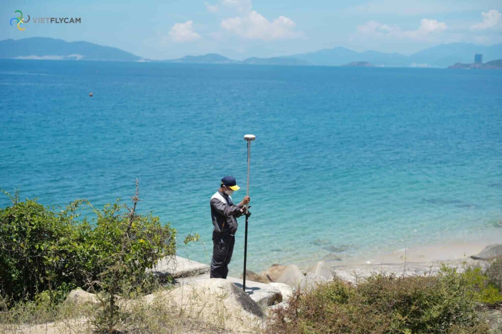
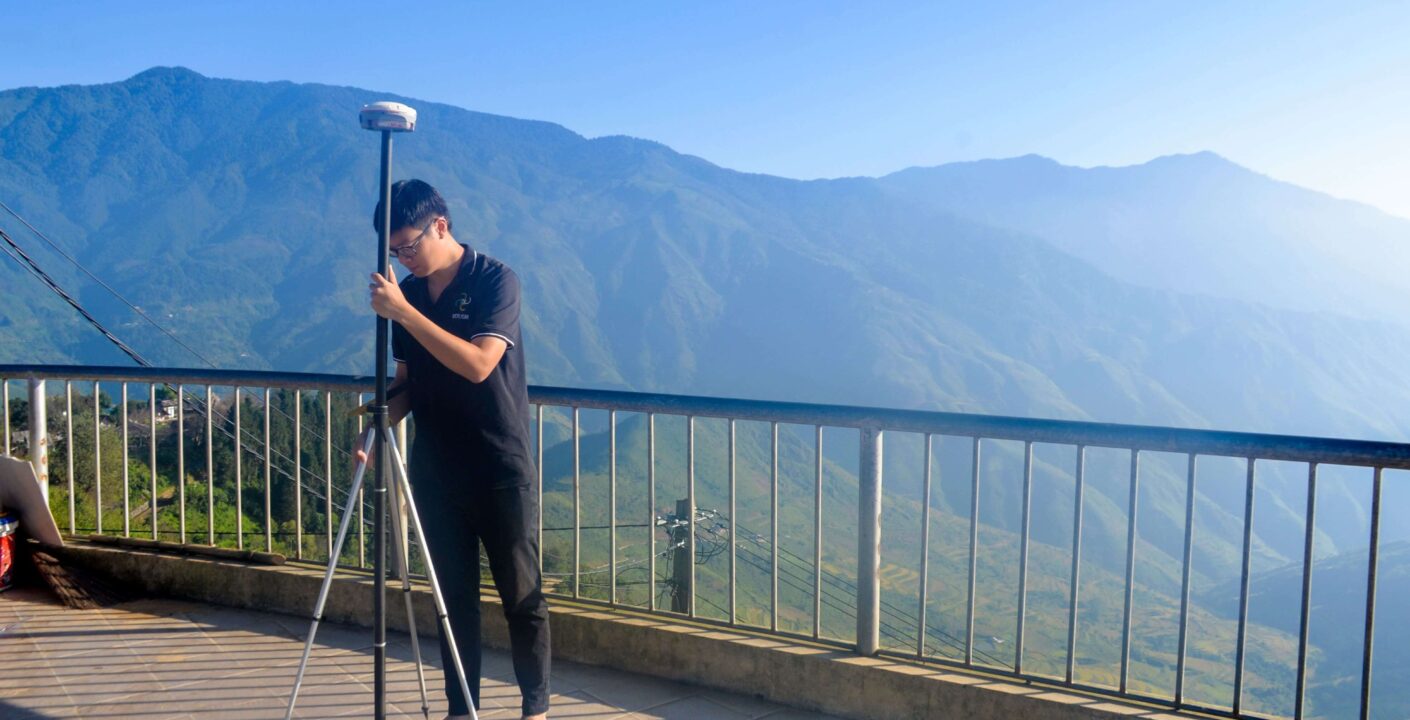
During the surveying process, the first step is to identify the national cadastral control points located near the survey area on the official geodetic benchmark map. This involves selecting two primary control points: one as the reference point and another to verify the X:Y coordinates of newly established points, ensuring high measurement accuracy and data reliability.
Next, the national elevation benchmark is determined to establish the Z-coordinate (altitude) of survey points relative to sea level. This step enables precise topographic measurement and elevation mapping, forming the foundation for accurate aerial surveying, UAV-based mapping, and 3D terrain modeling.
Step 2: Distribute Ground Control Points (GCPs) Across the Survey Area for Error Control
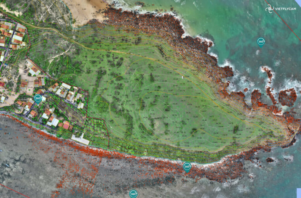
Ground Control Points (GCPs) are evenly distributed reference points measured according to the VN-2000 coordinate system to control positional accuracy. These points are linked to aerial images to ensure precise geo-referencing. The processed data then generates a high-accuracy orthophoto map and 3D terrain model, essential for drone surveying and mapping projects.
Bước 3: Tiến hành bay quét bằng flycam
Lần 1: Xác định dáng địa hình tổng thể của khu vực
Tiến hành bay toàn bộ khu vực để thu thập dữ liệu về dáng địa hình tổng thể bằng flycam. Quá trình này cung cấp cái nhìn toàn diện về địa hình, bao gồm thông tin về độ cao, độ dốc, độ lồi lõm, hình dạng địa hình và các yếu tố khác.
Lần 2: Bay scan 3D theo dáng địa hình
Việt-Flycam khác biệt với các đơn vị khảo sát khác bằng việc thực hiện bay scan 3D theo dáng địa hình, nhằm đảm bảo độ phân giải và độ chính xác đồng đều trên toàn khu vực đo.
Các tấm ảnh được chụp để xác định các địa vật, khu vực (đường xá, nhà cửa,…) và công nghệ trí tuệ nhân tạo (AI) được sử dụng để tự động khoanh vùng các khu vực có cây bao phủ để chuẩn bị cho bước lọc cây cối trên địa hình.
Dữ liệu thu thập tự động được xử lý bằng nền tảng tracdiaso để tạo ra sản phẩm bản đồ 2D độ nét cao và mô hình 3D tổng thể toàn khu vực.
Bước 3: Bay lọc bỏ lớp cây bằng công nghệ Lidar
Việt-Flycam tiến hành bay lần thứ ba theo các khu vực thực phủ được khoanh vùng từ lần bay thứ hai, sử dụng công nghệ Lidar để lọc bỏ lớp cây.
Đối với các khu vực phức tạp như rừng, cây bụi, thực phủ dày đặc, Việt-Flycam sẽ thực hiện đo đạc lại bằng công nghệ RTK để đảm bảo độ chính xác cho toàn khu vực.
Kết quả của quá trình này là dữ liệu đầy đủ về mặt đất và các yếu tố trên ngọn cây, giúp cung cấp thông tin chính xác về địa hình và môi trường trong khu vực khảo sát.