VDCD

brand story.

vdcd group

VIET NAM DESIGN AND CONSTRUCTION TECHNOLOGY JSC.

Abbreviation VDCD

Business Registration Certificate No.: 2700338327

VDCD operates across multiple high-tech sectors serving civil, military, and national security applications.
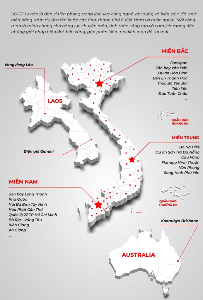
1. VDCD Corporation was established in 2006 and currently comprises 10 member companies and 9 representative office buildings nationwide. The corporation employs over 400 personnel, including 250 professors, PhDs, MScs, engineers, and top industry experts trained at leading technology universities in Vietnam and abroad.

The company invests in and develops a comprehensive portfolio of high-technology services, including Unmanned Aerial Vehicle (UAV) systems, aerial surveying and digital mapping, geospatial database digitization, regional and real estate master planning consultancy, software system development, data center construction and operation, as well as the manufacturing of robotics and advanced Artificial Intelligence (AI) solutions.

2. A dedicated research system established at Hanoi University of Science and Technology, specializing in the development, manufacturing, and operation of Unmanned Aerial Vehicles (UAVs) and autonomous underwater vehicles.

3. A nationwide network of supercomputer data centers and AI analytics & training facilities, strategically invested and deployed across Hanoi, Ninh Binh, Quang Ngai, Binh Dinh, and Ho Chi Minh City.

core capabilities.

VDCD owns proprietary core technologies and a team of leading experts specializing in digital transformation, high-precision data processing based on BIM & GIS standards, and the development of advanced, industry-specific software solutions.

solutions.

Fields of Operation

Technology solutions
  • Digital Transformation Consulting & Implementation
  • IT Infrastructure & Cybersecurity Architecture Consulting
  • Customized Enterprise Management Software Development
  • 360-Degree Sales Management Systems
  • AIoT Solutions, Smart Manufacturing & Intelligent Factory Systems
  • Integration of E-Invoices, Logistics & Delivery Systems
  • AI Image Processing & Computer Vision Systems
  • Blockchain Applications: Exchange Platforms & Asset Tokenization
  • Timelapse Camera Solutions for Monitoring & Image Analytics
  • SmartScale – Intelligent Weighing Station Management System
Survey consultation
  • Aerial Topographic Surveying with High-Resolution Drone Data
  • Production of 2D and 3D visualized maps for comprehensive spatial understanding.
  • Assessment of existing site conditions, construction areas, and natural terrain features.
  • Accurate measurement of elevation, area, volume, and technical parameters
  • Development of digital terrain and surface models to support design and planning.
  • Comparison and validation of surveyed data against design drawings for quality control.
  • Capture of panoramic images and videos to support project management, monitoring, and reporting.
Design consultation
  • BIM Technology Solution Consulting & System Design
  • Industrial Park Planning & Design Consulting
  • Functional Area Planning & Design Consulting
  • Urban Area Planning & Master Planning Consulting
  • Rural Residential Area Planning & Design Consulting
  • Rural Residential Architecture Design
  • High-rise Building Design Consulting
  • Public Investment & Government-funded Project Design Consulting
  • Low-rise Residential & Civil Construction Design
  • 3D Rendering & Architectural Animation Production
  • Virtual Reality (VR) Spatial Modeling
  • Digital Virtual Model (Virtual Maquette) Development
  • Project Management & Construction Supervision Consulting